Travel Directions and Local Attractions
It’s easy to get to Pendle Hill thanks to our convenient Philadelphia-area location. We are close to major metropolitan transportation hubs like the Philadelphia Airport and Bolt station (about 25 minutes from each), local bus and SEPTA routes, a five-minute drive from Media and Swarthmore (including Swarthmore College), and 20 minutes from Bryn Mawr and Haverford Colleges. We look forward to seeing you soon!
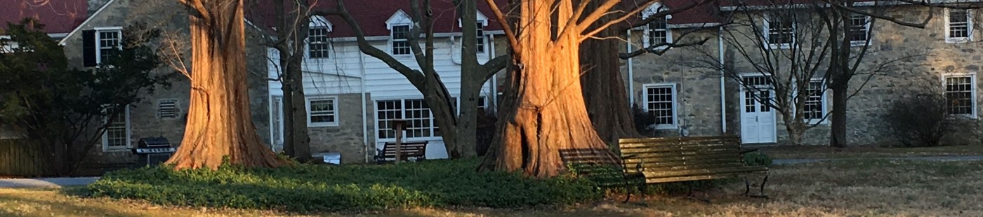
Main Campus
338 Plush Mill Road
Wallingford, PA 19086-6023
610-566-4507
Brinton House Conference Center
321 Plush Mill Road
Wallingford, PA 19086-6023
610-566-4507
Pendle Hill Hospitality Line – 610-613-7660
Travel Directions
TRAIN
Amtrak and SEPTA trains arrive at Philadelphia’s 30th Street Station. From 30th Street Station or from Market East Station, take the SEPTA Media/Wawa Local. Get off the train at Wallingford.
If you wish to walk from the train station to campus, we recommend the following directions, as these will differ from directions available on any maps software. The directions recommended by maps software takes travelers a circuitous and dangerous route down Turner Road. Here are some alternatives:
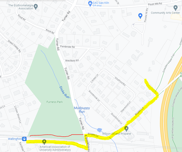
Click to enlarge
To walk mostly on a path through the woods: once exiting the train, do not cross over the tracks to the street-side; rather proceed to the end of the platform in the direction from which the train came, and take the wide mulched path that opens to the left at the end of the platform, always staying to the left at crossings. This will take you through Furness Park and to a pedestrian crosswalk where Turner Road and Roger’s Lane intersect. Cross Turner Road and immediately also cross the small connector road for vehicles turning right from Turner Road onto Roger’s Lane, and then proceed along the sidewalk on Roger’s Lane. At the bottom of a small hill, the sidewalk disappears for a short time crossing a small bridge – proceed with caution. On the other side of the bridge, proceed up the hill on the sidewalk until you see the sign for Pendle Hill across the street, shortly before a very large bridge. This is a back entrance which connects to the footpath, bringing pedestrians in by the garden, the maintenance building, and Firbank.
To walk mostly on sidewalks: exit the train and cross the tracks (when able) to the station / street-side. Cross the street and proceed to your left on E Possum Hollow Road. At the intersection, cross to the other side of E Possum Hollow Road in the pedestrian crosswalks, and then follow the sidewalk to cross the train tracks. At the next pedestrian crosswalk, cross Turner Road and immediately also cross the small connector road for vehicles turning right from Turner Road onto Roger’s Lane, and then proceed along the sidewalk on Roger’s Lane. At the bottom of a small hill, the sidewalk disappears for a short time crossing a small bridge – proceed with caution. On the other side of the bridge, proceed up the hill on the sidewalk until you see the sign for Pendle Hill across the street, shortly before a very large bridge. This is a back entrance which connects to the footpath, bringing pedestrians in by the garden, the maintenance building, and Firbank.
CAR
- From I-476 SOUTHBOUND take Exit 3, Baltimore Pike (Media/Swarthmore); turn right onto Baltimore Pike; from Baltimore Pike take the first left onto Turner Road; take second left onto Plush Mill Road. Pendle Hill is about 200 yards on the right.
- From I-476 NORTHBOUND take Exit 3 Baltimore Pike (Media/Swarthmore), turn left onto Baltimore Pike; from Baltimore Pike take the first left after the intersection and light onto Turner Road; take second left onto Plush Mill Road. Pendle Hill is about 200 yards on the right.
- From Philadelphia, Pa., and the Philadelphia International Airport follow I-95 South to Exit 7, I-476 North (toward Valley Forge). Follow directions above: From I-476 Northbound.
- From northern New Jersey, New York, and points north follow NJ Turnpike South to Exit 6, I-276 West (Pa. Turnpike); 1-276 to Exit 25A, I-476 South (toward Chester). Follow directions above: From I-476 Southbound.
- From southern New Jersey take US 322 West and cross the Commodore Barry Bridge; right onto I-95 North to Exit 7 to I-476 North (toward Valley Forge). Follow directions above: From I-476 Northbound.
- From northern Pennsylvania via Northeast Extension, I-476: Northeast Extension of Pa. Turnpike South, I-476 South (toward Chester). Follow directions above: From I-476 Southbound.
- From western Pennsylvania via Pa. Turnpike, I-476: Pa. Turnpike East (I-76) to Exit 24 (Valley Forge); continue East on I-76, Schuylkill Expressway to Exit 331A: I-476 south (toward Chester). Follow directions above: from I-476 Southbound.
- From Baltimore, Washington, D.C., and points south via I-95: I-95 North to PA Exit 7, I-476 North (toward Valley Forge). Follow directions above: From I-476 Northbound.
BUS
If traveling by Greyhound or Trailways, follow the signs in the bus terminal to Market East Railway Station. At the station, take the Media/Elwyn Local and get off at Wallingford.
TROLLEY
The SEPTA trolley route 101 runs from 69th Street Terminal to Media every 20-30 minutes. Septa Key Cards may be purchased at the Terminal. Get off the trolley at the Providence Road stop.
PLANE
If flying into the Philadelphia Airport (PHL), it’s simple to call an Uber or Lyft to bring you the 15 minutes to Pendle Hill. There are also options for cabs and shuttle services from the airport.
Local Attractions
Nearby towns include:
- Wallingford (10 to 20-minute walk): Train station, small grocery store, church, schools, library, and post office.
- Springfield Mall (15-minute walk): A large, covered shopping center with many stores selling clothing, furnishings, tools, gifts, etc. Has restaurants, and a Target with a grocery store.
- Swarthmore College (25-minute walk): A beautiful campus with wide variety of trees. There are coffee shops, restaurants, and small stores in the nearby town of Swarthmore. A map of the college is available at www.swarthmore.edu/campusmap.
- Media (20 to 30-minute walk): County government center. Many shops, grocery store, post office, banks, library, restaurants, churches, and synagogues.
Local Quaker Meetings include:
- Swarthmore Friends Meeting – 1.2 miles from Pendle Hill, 25 minute walk
- Providence Friends Meeting – 1.4 miles from Pendle Hill, 30 minute walk
- Media Friends Meeting – 2 miles from Pendle Hill, 40 minute walk
There are additional Friends Meeting Houses within 10 miles of Pendle Hill, some dating back to the 1600s.
GETTING AROUND
Ubers, Lyfts, taxis, and limos can be called upon from Pendle Hill. To ensure you meet your driver at the correct location (including meal delivery services like DoorDash and Grubhub), be sure to meet them at the entrance on Plush Mill Road, or direct them to the gravel parking lot on the first left after entering the driveway.
Train and trolley stations are within walking distance from Pendle Hill’s campus. The SEPTA Regional Rail at Wallingford station will take travelers on the Media Wawa Line into Philadelphia. The SEPTA trolley station on Providence Road will also take travelers to the Springfield Mall and 69th Street and into Philly via the 101 Route.
Bikes can be safely locked or parked on campus, with some available to borrow. We ask that riders wear the proper safety gear.